Good morning. This is Dave Zinn with the Gallatin National Forest Avalanche Forecast on Tuesday, April 11th, at 7:00 a.m. This is our 140th and final forecast for the season. Thank you to the readers of the forecast, and everyone that sent in observations, took an avalanche class, or donated money, time, or gear. Our success is directly related to support from our community and the Forest Service. Thank you for another great season. We will continue to make relevant updates to the website and social media through the spring and issue general updates on Mondays and Fridays.
This forecast does not apply to operating ski areas.
Mountain temperatures remained above freezing for the second night in a row, with lows in the 30s and 40s F. Winds ramped up to 10-30 mph from the south to the west and will increase through the day, averaging 20-45 mph. High temperatures will range from the upper 40s F to near 60 degrees F. Temperatures will likely drop below freezing tonight, and a potent spring snowstorm will move into the area Wednesday night.
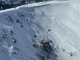
Very dangerous conditions for wet snow avalanches exist across the advisory area, without freezing temperatures for 48 hours in all but the highest elevations. Slides will entrain wet surface snow, endangering humans in their path, or break out as large slabs of flowing concrete-like snow that could level sections of forest. They may run long distances, crossing groomed roads, ski runs (this one’s for you, Bridger Bowl tourers), and even highways below steep snow-covered terrain (photos and details). Yesterday, a pilot flying over the area noted, “Too many point releases (wet loose avalanches) to count in every range I’ve crossed” (observation and photos). Alex saw five natural avalanches large enough to bury or injure a person and many smaller slides in the Bridger Range (details). The Big Sky Ski Patrol closed terrain to manage the danger and saw full-depth, wet loose snow avalanches on aspects that face the sun (details).
The warm-up is weakening cornices and sending blue whale-sized blocks tumbling downhill. We received an aerial photo of a new cornice collapse in the Northern Madison Range (photo and details). On Sunday, a backcountry skier near Big Sky Resort had a close call when they triggered a cornice that, in turn, triggered a deep avalanche on the slope below (details).
Keep wintery avalanche problems like wind slabs and persistent weak layers in mind, especially with a snowstorm forecast to start tomorrow. Last week’s storm brought large avalanches breaking on persistent weak layers to the Northern Madison Range, Southern Gallatin Range, Lionhead Area and Bridger Range.
The danger from wet snow avalanches starts the day as CONSIDERABLE and will increase to HIGH. Traveling on or below steep slopes is not recommended.
With slightly cooler temperatures, the mountains around Cooke City are a day behind those elsewhere in the advisory area. Temperatures remained above freezing last night, and riders observed many small, wet loose snow avalanches and a large cornice fall near Mount Abundance (photos). Anticipate larger avalanches today, giving yourself a wider margin below steep sun-soaked slopes, as slides could run into the flats.
Wintery avalanche problems are not done for the season. Recent slides involving wind slabs occurred as recently as last Thursday, and deeply buried weak layers produced avalanches a week ago (skier-triggered wind-slab, Natural Wind-slab 1, Natural Wind-slab 2, Deep slab Mt. Abundance, Deep slab Woody Ridge). Tomorrow, cooler temperatures and snow return, and these problems will return to the forefront.
The avalanche danger is CONSIDERABLE due to the wide array of avalanche concerns, including increasing wet snow danger throughout the day.
Please continue to share avalanche, snowpack or weather observations via our website, email (mtavalanche@gmail.com), phone (406-587-6984), or Instagram (#gnfacobs).
Upcoming Avalanche Education and Events
Hyalite Canyon road is closed for motorized use until May 16.


